High Sierra Trail & John Muir Trail, Segment Two: 107.2 Miles, +19,000'
August 10, 2012: Onion Valley Trailhead To Woods Creek Junction, 18.6 Miles, +3,900'
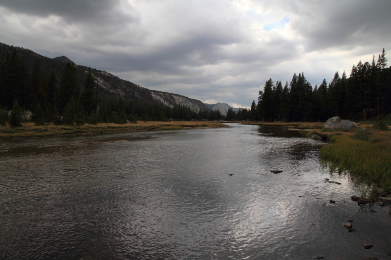
I was back on the trail at 0730 after a great break from it. Immediately I was missing Judy, it was going to be tough being away another ten days. I blazed up the trail and arrived at Kearsarge Pass at 0930. The weather was beautiful sans a stormy patch to the southwest and it was building fast. I made my way down to the JMT and headed north towards Glen Pass. The skies were growing darker as I climbed on. I didn't want to be caught in a lightning storm this high above tree line. I arrived at the pass at 1115 just as it started to sprinkle. I took off my pack to enjoy one of my two pieces of delicious pepperoni pizza from Little Caesars (I got some evil glances from JMT folk as I ate my prize :o ). After eating my lunch I geared up for the weather; rain jacket, pants, pack cover and camera rain cover. Glen Pass is at 11,978' and at 11,500' the thunder and lightning started just to south. Again, not a good feeling being in a lightning storm up this high. I just motored down the trail hoping for the best. I made it to treeline and the first of the Rae Lakes and was able to exhale a little. This is not enjoyable hiking. Another negative for me is the lack of photographic opportunities as my camera is tucked away in its rain gear coupled with the dark gloomy skies makes for an unhappy Jim :(
I hurried my way through the Rae Lakes with the occasional flash in my peripheral and thunder crack to get me moving even faster. The Rae Lakes are a very beautiful and serene place, but I wouldn't be stopping to smell the flowers here. The rain was more of a steady sprinkle until I got to Dollar Lake, there it really started to pour. I took refuge in the trees and hoped to wait out the storm, but I had some company. A firefighter from San Diego who was headed southbound waited with me. For about two hours the thunderstorm raged, sometimes in vicious downpours and lightning strikes. Finally at 1500 hours I could see some blue sky opening up around me. I thanked my firefighter friend for the company and I continued down to the Woods Creek junction. It didn't rain anymore but the skies above never cleared until sundown. As expected I had alot of company at this very popular campsite, mostly Rae Lake loopers. Apparently it had not rained all day down here (8400') and all the rain occurred up high. I was able to dry out and enjoy dinner. What a day.........
 |
| A Most Wonderful Send Off |
 |
| Mt. Brewer & Bullfrog Lake |
 |
| The Rugged Kings-Kern Divide |
 |
| Glen Pass From The South |
 |
| Here Comes My Daily Rinse Off |
 |
| T-Storms Over Diamond Peak |
August 11, 2012: To Upper Basin (Elev. 10,900'), 14.6 Miles, +4,700'
Got a good peaceful night of rest and was up and at em ready to go at 0630 hours. The weather was great to start off the day, clear cloudless blue skies, we'll see how long that lasts. (Every clear morning would give me hope that the weather had changed). I had 7.6 miles till Pinchot Pass and I would go from 8400' to 12,100' in that stretch. I enjoyed the hike up with the ever changing scenery with each thousand feet of gain. I had it all to myself too, no one in sight. This section seemed really remote. I arrived at Pinchot Pass at 1015 and took a small break. There were a few cumulus clouds to the west that I would have to keep an eye on. From the top of the pass you have a grand view of Upper Basin, the South Fork Kings River and beyond to the Palisades. To the northwest is Mt. Ruskin, a very pleasing looking mountain that I would like to climb someday. I could also look all the way north to the next formidable obstacle; Mather Pass ten miles away. I started to have visions of crossing over Mather Pass, I was ahead of schedule and felt great, but mother nature would decide my fate, did not want to get caught on a 12,000' pass in a lightning storm.
I descended the north side of Pinchot Pass under a 50/50 threatening sky. The scenery is great in the basin between the two passes, I definitely want to come back to this area to explore, peak bag and relax, particularly Arrow Peak, Bench Lake, Cardinal Mountain, Taboose Pass, Mt. Ruskin, Mt. Wynne and Mt. Pinchot, its all so good. I refilled my water bottles at striking Lake Marjorie. Someday I will camp here, its a must see. I continued down, down, down to the South Fork of the Kings River. Last year when I was here it was a wet and wild crossing, but in this low snow year it was an easy boulder hop. The weather was holding steady and the idea of getting over Mather Pass was gaining momentum. As I neared tree line just under 11,000' I had to choose my fate. If I continued on the two and a half miles to the pass I would be doing so without any cover and it would still be an additional two miles down the other side to the first decent camping in the trees. The skies north and east of me were clear, but dark and ominous south and west of me. After careful consideration I chose the conservative approach and found a decent campsite just at treeline at 10,900'. I set up my camp, had a snack and refilled my water supplies. Within half an hour I could hear the booming of thunder coming over the mountains west of me and before too long the flashes of lightning. The storm clouds quickly enveloped the blue skies and once again I was hunkered down in a rain/thunder/lightning/hail storm. It lasted about three hours this time. I was dry and happy reading my Star Wars books all the while patting myself on the back for making a safe and sound "solo hiker" decision because I did have a good notion to push through, but in the end Mother Nature and past experiences won out and I stayed in the safety of the trees. I went to sleep early with an early push the next morning planned. This trip was turning into a hike early/camp early routine.
 |
| Early Morning Light On Mt. Clarence King |
 |
| Crater Mountain |
 |
| Mt. Clarence King |
 |
| Pinchot Pass |
 |
| First View Of The Palisades |
 |
| Looking Down At Lake Marjorie |
 |
| Upper Basin, Mather Pass & Middle Palisade |
 |
| My Friend The T-Storm |
 |
| Here It Comes |
 |
| Nice Liitle Camp At 10,900' In Upper Basin |
August 12, 2012: To Le Conte Canyon Ranger Station, 17.4 Miles, +2,100'
Another great night of sleep. I replaced my Thermarest Z-Lite with a Neo Air before the trip and my oh my am I glad I did. I slept warmer and more comfortable just about every night, highly recommended. I woke up at 0515 and hit the trail at 0620. At day ten I was getting really efficient at making and breaking camp. I felt good about the weather, I only had two and a half miles to Mather Pass then a 4000' drop to the Middle Fork Kings River, so if it did storm I would be heading down and into the trees. The hike to Mather Pass was great, one of the best scenes yet. The small tarns, Vennacher Needle and mighty Split Mountain plus the warm early morning light, this was fun hiking. I made it to Mather Pass at 0800 hours and felt great. I bid farewell to the Upper Basin and was blown away by the Palisades Lake basin which is dominated by the major Palisades peaks. Middle Palisade, Norman Clyde, Mt. Sill, Starlight, Polomonium, Thunderbolt and the grandest, North Palisade. I want to climb them all, someday. I spent a half hour on the pass taking photos and soaking in the scene, good times.
As I headed down to the Palisades Lakes my good friend the cumulus cloud started to make an appearance to the west, but I still felt good heading down the canyon. I talked to some southbound JMT folk and was told of the hail storm they received last night, there was still hail in the shaded areas of the trail. I stopped and sat a bit at the Lower Palisade Lake, refilled water and had a delicious protein smoothie from Pack It Gourmet. My food choices for the trip were oatmeal and peanut butter for breakfast. bars and trail mix for snacks, smoothies for lunch, Mountain House meals for dinner and M & M's for desert. I always had the energy I needed and was mostly satisfied with the variety and flavor. After my lunch I began the long steep descent down the "Golden Staircase" to Deer Meadow. The view down canyon to the Middle Fork Drainage and across to the Devils Crags is impressive. This was the last section of the JMT to be built, it was much more enjoyable going down this route as opposed to last years ascent. I made it down to the forested Deer Meadow as I heard the first cracks of thunder to the southwest of me, still felt good going down. I even stopped for a foot soaking break along Palisade Creek which felt great. I have been able to stay blister free on the JMT the past two years and 547 miles by changing socks midday after a cold soak.
I proceeded down the JMT to the Middle Fork Kings River junction when I felt the first rain drops. Within minutes it started to rain in earnest. I found a cluster of dense trees and took shelter hoping the rain would pass. After ten minutes of consistent rain I made the decision to put on all my rain gear and pack cover as my shelter was now letting in the rain. I was in no mans land in regards to a campsite so I would have to push on for three miles to the Ranger Station. Up until now the thunder and rain had been moderate, but as soon as I made the choice to hike in it, well, it got much worse. The lightning and thunder were directly overhead it seemed, the old wait for the lightning to strike and count till the thunder was a quick flash, one, two, boom. The rain grew heavy and the trail became a river. I pushed on through the torrent and eventually made it to the Bishop Pass junction where I set up a wet camp. All the flat spots had become small pools of water so I made camp on the uneven drier forest floor. I set up as fast as I could to minimize water getting into my tent and gear (sadly I am getting to be a pro in this fine art). I was finally able to relax at 1530 hours, but it was still pouring and it wouldn't let up until 1800 hours. Everything was soaked and would not likely dry out overnight. I ate my dinner in my vestibule, read some more and fell asleep. What a wet and soggy day.
August 13, 2012: To Mc Clure Meadow Ranger Station, 17.8 Miles, +3,600'
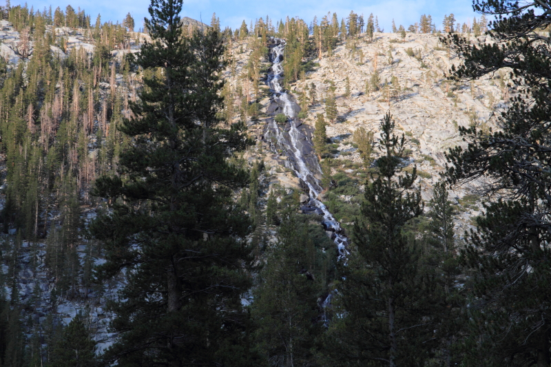
I woke up at 0400 after a wet night of rest. The rain stopped at dusk, but nothing would dry overnight. I did my best to soak up as much water as possible before stuffing everything wet in my bag, but it was inevitable, my gear would stay wet throughout the day :(. I set foot on the trail at 0554 towards Muir Pass. I had about eight miles to go to the pass and did not want to get caught up there in a storm. Muir Pass is beautiful but it goes on for miles on either side high above tree line. Probably the worst of the passes behind Forester to get caught in a storm, so I had my work cut out for me today. The walk along the Middle Fork Kings River was spectacular this morning, very peaceful and serene. The alpine glow off of the Black Giant was the highlight. I enjoyed this view for many miles. I was able to rotate various clothing items (jacket, pants, shirts, socks) while hiking in an attempt to dry, for the most part it worked.
The north side of Muir Pass is a long long slog up a very beautiful trail. Normally sierra passes are shaped like pyramids, no nonsense up then down, but not Muir Pass. It is a very long and gradual climb out of Le Conte Canyon over many miles. You are above treeline most of the way which makes for swell views. I passed many lakes and cascades, the dry year did not affect this area much. I made it to the pass at 1015 hours and stopped for a short break. Clouds were really building fast and based on yesterday, would be dropping some water and power soon.
Quick side story: On the way up to the pass I ran into a family of four (dad, mom, two young girls) and they told me of a terrible night at the hut located on Muir Pass. They got caught the previous night in a wicked storm (most of us did), but they were on the pass many miles from shelter. They attempted to get into the hut and wait out the storm. There was one person in the hut who refused to let them in. He blocked the door with his backpack and a rock. In desperation the dad pushed the door in and gained access. He was ready for a fight from the a-hole inside but the a-hole just faced the wall and never spoke a word the entire night. The a-hole woke up early in the morning and proceeded to lock the family in the hut from the outside. The family could not get out and waited two hours for a passer by to unlock the door. That could have been a dangerous situation, just goes to show there are shitheads everywhere, even the mountains.
As I left Muir Pass I also left the Kings River drainage behind and entered the San Joaquin River drainage on the north side. Kings River water to the Central Valley, San Joaquin water to San Francisco Bay. Again, amazing thing to me :). I was going to have to make great time if I wanted to beat the storm to tree line. It is a shame because this is an area worth staying at. Mt. Goddard, Wanda Lake, Mt. Solomons and Mt. Huxley then Mt. Darwin, Mt. Mendel and Sapphire Lake farther down the trail. An amazing sight indeed, another spot I want to explore in depth down the road. I arrived at equally stunning Evolution Lake at noon when I felt the first drops and heard the distant thunder. I immediately put on the rain gear and kept on moving. It rained for about an hour until I arrived at tree line heading into Evolution Valley. I was able to complete the days trek to camp rain free which was very welcomed after yesterdays fiasco with the weather. I set up camp near the Mc Clure Meadow Ranger Station. I set up my camp near the meadow and enjoyed the rest of my afternoon high and dry :). I was able to dry out last nights wet gear and just relaxed. A number of southbound JMTers would show up throughout the afternoon and we all shared our stories.
I spent a good amount of time down at the river that winds thru Evolution Valley taking photos and soaking in the views. I was able to witness and photograph a spectacular sunset. The glow off the Hermit and Mt. Mendel and Darwin was out of this world. Good times indeed. With Muir Pass behind me I am now through the biggest passes of the trip. I went to bed feeling pretty good about the rest of the trip...........
 |
| Middle Fork Of The Kings River High Above Le Conte Canyon |
 |
| The Black Giant |
 |
| Helen Lake Reflections |
 |
| More Of Helen Lake |
 |
| Another From Helen Lake |
 |
| Muir Pass |
 |
| Looking North From Muir Pass |
 |
| Mt. Goddard |
 |
| Mt. Darwin & Mt. Mendel |
 |
| Getting Stormy Again............ |
 |
| Sunset From Camp Looking At Mt. Mendel & Darwin |
 |
| Evolution Meadow Sunset |
 |
| Alpine Glow Off Of The Hermit |
August 14, 2012: To Sallie Keys Lake, 17.9 Miles, +2,800'
I was up and on the trail by 0700 today. Got a great nights rest and was feeling very enthusiastic about the day ahead. If I got there early enough I wanted to swing by Muir Trail Ranch to send my wife an e-mail saying hello and updating her on my progress, mail out a post card and check the long range weather forecast, it had to be stabilizing soon, right??? A bonus would be the hoards of extra backpacking food that was available in the overflow barrels (backpackers can mail themselves packages of food to be held at the ranch and leave behind food and or supplies they don't need or want anymore).
I made excellent time down the canyon and was really enjoying the day. The Evolution Creek crossing was easy, I still had to take my boots and get knee deep in the river, but nothing compared to last years chest deep adventure. In fact, this was the only wet crossing all trip, last year I had over forty :o. I kept on trekking down the canyon and before long reached the boundary between Kings Canyon National Park and the Sierra National Forest. The weather looked okay, not terrible but building at 1000 hours. I made it to the Muir Trail Ranch cut off in great time and decided to give it a go. I arrived at the ranch at 1015 hours and was ready for a snack. There was quite the bounty in the hiker barrels, I scored some Spam, M&M's, BBQ Lays, Drink Packets, Beef Jerky and Fritos, good times. I was able to get an e-mail to my wife with an update on conditions. I was right on schedule despite the conditions. I mailed out a couple of postcards and checked the weather forecast. Any hope of a pattern shift was dashed, the next seven days was as follows: 40-60 % of Thunderstorms :(. On cue, it started to rain while reading the weather forecast. I ate my lunch and geared up for a wet trek up to Sallie Keys Lake five miles and twenty five hundred feet up.
I started up the steep cut off trail back to the JMT with some light rain. There was an occasional lightning flash northwest of me and accompanied by the booming thunder. The trail heading up to Sallie Keys Lake is a south facing manzanita covered slope. Not much protection from the weather. The thunder makes me move faster, that combined with the constant uphill and rain gear made for a sweaty affair. I decided to shed my rain pants and wear shorts and just my rain jacket, I was getting just as wet from the sweat as I would have from the rain, this would become problematic later in the day. At 1330 hours it really started to rain then hail. I pushed through it as there was nowhere to make camp. The rain was relentless, the trail turned into a river that was hard to follow at times. My gear did what it was supposed too, but the combination of working hard uphill and pouring rain that went on for hours equaled a wet Jim. The higher I went the colder it got too which really concerned me. I really needed a break in the weather to dry out, but would not get it. I started to get very concerned with my predicament. I stopped at 1500 hours to get things straight in my head. It was still raining hard and did not appear to be stopping any time soon. I was a mile and a half from the lake and decided to push on, just stopping for two minutes brought on some shivers, not good. The rain did not let up as I moved closer to the lake. I was now very concerned about getting chilled the minute I stopped to set up camp. My fingers were going numb, my core was cold and my mind started to drift to a bad place. Negative thoughts crept in and feelings of despair started to manifest themselves. I really wanted wished I had a partner right about now as there was no one in sight. I had to force in some good thoughts, I had a sleeping bag in a dry sack with some dry socks, beanie and down jacket. If I could set up camp fast enough, I could get out of the rain and cold and warm up. I focused on getting warm and not much else. I arrived at the normal campsites to find them all pools of water so I went a little higher and found a patch of sand to make camp. As soon as I stopped I started to shiver and the feelings of despair were back. It was tough doing anything with numbing fingers. Setting up the tent wasn't easy but I did it. I quickly got in, stripped off my wet clothing and got into the sleeping bag. I was still very cold so I did sit ups and push ups to generate some warmth and it worked. As my body warmed I started to think about what's next. I needed to eat dinner but did not want to get out of my sleeping bag. I needed to get water as well, but most of all I needed to get my gear in order. As I was setting up camp I neglected the fact that everything had become covered in sand, the wet sand was everywhere. I did my best with a wet bandana to clean things up. I made a clothesline inside my tent and vestibule to attempt to get some clothing dry. It was 1900 hours and still raining.
The rain finally stopped at 1930 hours and I was able to get out of my tent, get water and make dinner. It was lonely and cold, but I was dry. I took out all my wet gear and hung it all out to dry and rocks and tree limbs with the hope that the night air might dry it out. This was a not so fun day. Looking back I should have made camp farther down when the rain wouldn't stop, but I did not know that then. I kept waiting for a break in the weather that did not come. I can see how these situations can get out of hand in a hurry and will tuck this experience in the back of my mind if I should ever be faced with it again. Hunkering down dry and warm is always the better decision than getting soaked and cold.
 |
| Cascade Down Into Evolution Valley |
 |
| The LeConte Divide |
 |
| The South Fork Of The San Juaquin River |
 |
| San Juaquin River |
 |
| Exiting Kings Canyon & Entering The John Muir Wilderness |
August 15, 2012: To Vermillion Valley Resort, 17.7 Miles, +1,900'
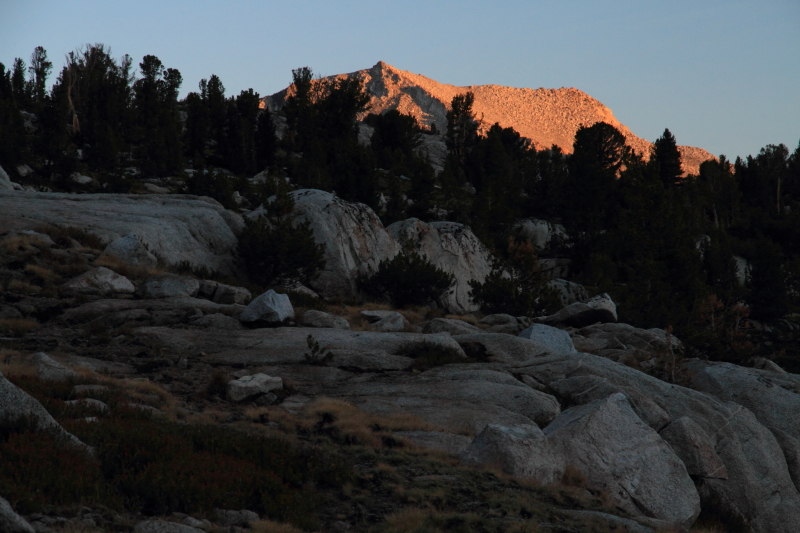
I actually slept well despite the cold and wet conditions, I was warm and toasty in my sleeping bag all night. My mood was greatly improved after a nights rest. I woke up at 0400 hours so I could get to the Vermillion Valley Resort early. The hot shower was my driving force. I was treated to a meteor shower and clear skies which was great. My gear had indeed dried out enough over night and I was able to pack up dry and hit the trail at 0530 hours. I made great time up to Selden Pass and down to Marie Lakes. Here I talked to a couple of southbound JMTers who didn't fare much better on this side with the weather. I wished them well and continued down down down to Bear Creek. The Bear Creek crossing is known as a doosy, but this year it was an easy boulder hop. I passed the junction with Italy Lake before having my morning snack. This is another area I would like to explore, particularly Mt. Hilgard. The skies were clear and I was feeling good about making it to VVR high and dry.
The Southern California Edison Problem: Cutting a path between the Silver Divide to the north and the Mono Divide to the south is Mono Creek which begins high on the flanks of Mt. Mills and Mt. Abbot, Mt. Gabb and the many Recess drainages. Southern Caifornia Edison dammed Mono Creek to create Lake Thomas Edison and farther down canyon Shaver Lake. SoCal Edison decided to do maintenance on the dam at Shaver Lake and drained most of it in the spring months. Shaver Lake is a very popular recreational lake and being a very dry year and having a need to fill it, they drained a lot of water from Lake Edison. Why is all this important you ask, well it is a five mile one way walk from the JMT/Mono Creek junction to VVR. In normal years the folks at VVR operate a shuttle boat to get the backpackers across the lake and to their waiting re-supplies, but with the lake being so low, they were not able to operate the shuttle. So, the extra ten miles round trip was something that just had to be done.
There is a cutoff trail (Bear Ridge Trail) that leaves the JMT and takes a direct line around the southern end of the lake. I took this trail and went steeply downhill for 5.6 miles to the dam. I was amazed at how low the lake level was compared to last year and could see why the ferry was unable to operate. From the dam it was a two mile walk on the rocky shoreline to the resort. I arrived there at 1230 hours, 17.7 miles in 6:40, that hot shower, meal and re-supply motivated me in a big way. There was only one other backpacker when I arrived, pretty lonely. I started my tab (everything is put on a tab, then when you check out you pay and are usually in shock at all that you spent) and received my bucket. It is always a pleasant thing to know your food re-supply made it to you, I am always slightly concerned that it won't be there waiting for you.
First thing I found in my bucket was a loving personalized card from my wife. At that moment it was exactly what I needed. I was having serious doubts about continuing, thunderstorms everyday were wearing heavily on me and after yesterdays episode I was all but done, but the motivation I found in her writing sparked me up again. Positive thoughts and feelings began to replace the negative ones. I was 2/3rds done with this journey, only six days to go and despite the conditions I was doing well physically. I sorted through my bucket removing items I would not need, mainly sunscreen (not much sun to date) and deet (no mosquitos :). I snacked on some yummy jelly beans my niece packed away for me and relaxed a bit. VVR offers hot showers and laundry (at a cost of $6 a piece) which I took full advantage of. It felt so good to soak in the hot shower, very rejuvenating. It stayed sunny for a couple of hours which allowed me to dry out my sleeping bag and tent. So by 1500 hours I had new food, clean clothes, dry gear, freshly showered and my devices were all fully charged, good times finally. It did start to rain however at 1530 hours for about an hour, but I was dry with a beer, still good times.
A few more backpackers arrived throughout the afternoon but it was mostly empty, the ferry not operating was taking alot of their business. We all chatted about the weather mainly (I wasn't the only one getting dumped on). For dinner I had steak, mashed potatoes and veggies that were delicious. After dinner I was able to make a phone call to Judy. It was the perfect ending to my day. I told her all about my trials and tribulations and she told me about things back home. It was really nice to talk, she told me to keep on trekking and to take an extra day or two if needed at Reds Meadow or Tuolomne (basically respect the weather and conditions and utilize my resources aka Reds/Tuolomne if need be). She told me I would regret turning back and it would all be worth it soon. I love her with all my heart, she truly is my soul mate and partner on this grand journey. Today was a good day.
 |
| Sallie Keys Lake |
 |
| Early Morning Glow |
 |
| Mt. Hooper |
 |
| The Mono Divide |
 |
| Lake Thomas Edison |
 |
| A Very Dry Lake Thomas Edison |
 |
| The Sierra Crest From Lake Thomas Edison |


No comments:
Post a Comment